Other
Advanced Techniques in 3D Architectural Visualization for Urban Design Projects | Panoram CGI

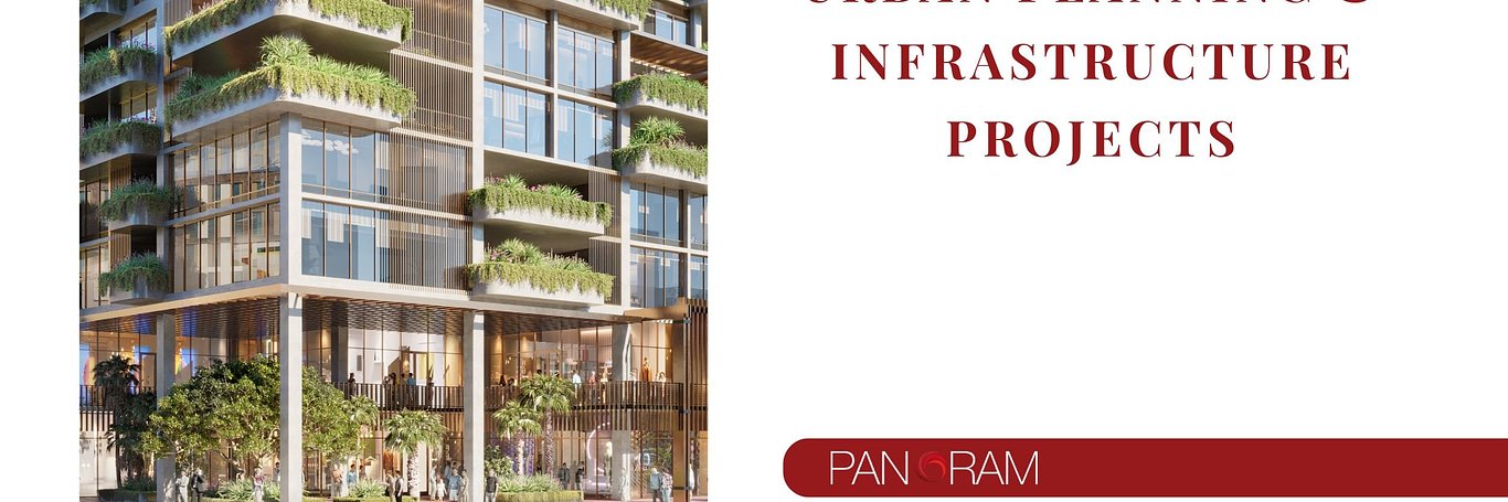
In the age of rapid urbanization and technological progress, urban planning and infrastructure development require more precise, efficient, and visually compelling tools than ever before. One of the most significant advancements in recent years is the application of 3D rendering. This technology has revolutionized how architects, urban planners, engineers, and developers visualize large-scale projects, enabling them to present and refine their ideas with a level of accuracy and realism that traditional methods can't achieve.
At Panoram CGI, our mission is to leverage cutting-edge 3D rendering techniques to bring clarity and creativity to complex urban planning and infrastructure projects. From visualizing transportation systems and residential neighborhoods to green spaces and large-scale commercial zones, we ensure your projects are meticulously designed, optimized, and ready to present to stakeholders.
In this comprehensive blog post, we’ll explore advanced 3D rendering techniques specifically designed for urban planning and infrastructure projects. These techniques not only enhance project visualization but also facilitate more informed decision-making, improve public engagement, and increase the likelihood of project success.
Why 3D Rendering Is Critical In Urban Planning And Infrastructure Projects
Urban planning and infrastructure are the backbones of modern civilization, determining how cities are shaped and how people interact with their environments. Accurate, efficient, and creative planning ensures that cities function smoothly, balancing the needs of their populations with the limitations of available space and resources.
3D rendering allows urban planners to create realistic, dynamic visual models of cities, buildings, transportation networks, and infrastructure systems, making it easier to anticipate potential issues and identify opportunities for improvement. By utilizing 3D visualization:
-
Better communication with stakeholders: Visualizing complex urban development projects in 3D offers stakeholders an immersive experience, enhancing understanding and reducing misunderstandings.
-
Improved design accuracy: High-fidelity visualizations allow for more precise planning and design.
-
Enhanced public engagement: A well-rendered 3D model makes it easier for the public to understand large projects, especially during public consultations or hearings.
Let’s delve deeper into some advanced 3D rendering techniques and how they can specifically benefit urban planning and infrastructure projects.
1. Photorealistic Rendering For Environmental Context
Photorealism is one of the most important techniques in advanced 3D rendering. This method creates extremely lifelike images, allowing urban planners and stakeholders to see exactly how a proposed project will look once built.
Applications:
-
Integration into existing environments: One of the key challenges in urban planning is ensuring new structures and developments seamlessly fit into their surrounding environments. Photorealistic rendering can demonstrate how proposed buildings will interact with existing infrastructure, vegetation, and urban spaces.
-
Lighting and material accuracy: By accurately rendering sunlight, shadows, and artificial lighting, planners can predict the aesthetic and functional impact of new projects under different conditions, whether day or night.
-
Real-world material simulation: Photorealistic rendering can emulate real-world materials like glass, wood, and steel, showing stakeholders how these materials will look and perform once implemented.
2. 3D Aerial Visualization And GIS Integration
One of the major benefits of 3D rendering for urban planning is the ability to generate aerial visualizations. When combined with Geographic Information Systems (GIS) data, aerial 3D visualizations provide an unparalleled bird's-eye view of entire cities, transportation networks, and environmental contexts.
Applications:
-
Large-scale project planning: Aerial visualizations help architects and planners visualize large infrastructure projects, such as highway expansions, new rail lines, or airport development.
-
Topographic accuracy: Integrating GIS data ensures that terrain, elevations, and natural features like rivers or hills are accurately reflected in the 3D models.
-
Environmental impact analysis: By integrating aerial and topographic views, planners can assess potential environmental impacts, like deforestation or water displacement, allowing for more sustainable planning.
3. Time-Based Simulations For Traffic And Infrastructure Flows
Urban planning doesn't just focus on static structures; it must account for how infrastructure will behave over time, especially when it comes to traffic and the movement of people. Advanced 3D rendering tools can simulate the flow of vehicles, pedestrians, and even public transportation systems over time.
Applications:
-
Traffic flow simulation: By simulating different times of day (morning rush, afternoon lull, etc.), planners can test how new roadways or intersections will affect traffic patterns. This leads to more efficient traffic planning and reduced congestion.
-
Pedestrian flow analysis: Understanding how people move through urban spaces is crucial for designing pedestrian-friendly areas, especially around public transport hubs, parks, and commercial zones.
-
Public transportation optimization: Using 3D models to simulate bus routes, train systems, and other public transportation can highlight potential bottlenecks and improve route efficiency.
4. Virtual Reality (VR) And Augmented Reality (AR) For Immersive Planning
Virtual and Augmented Reality have made significant strides in 3D rendering, especially when applied to urban planning and infrastructure. These immersive technologies allow stakeholders to not just see, but experience a project before it's built.
Applications:
-
Immersive walkthroughs: Stakeholders can take virtual tours of a planned development, walking through streets, parks, or buildings to get a feel for scale, layout, and design.
-
Real-time modifications: AR allows planners to superimpose proposed changes onto existing infrastructure, enabling real-time adjustments and comparisons.
-
Public engagement: Offering the public VR experiences of proposed changes during town hall meetings or online presentations helps them better understand the scope and impact of the project.
5. 3D Rendering For Sustainable Urban Planning
Sustainability is a key concern in modern urban planning, and 3D rendering can play a significant role in achieving eco-friendly goals. By using advanced simulations, planners can evaluate how projects will affect energy consumption, water use, and overall environmental impact.
Applications:
-
Energy efficiency analysis: By simulating how buildings will interact with sunlight and weather, planners can optimize designs for passive solar heating, natural ventilation, and other energy-saving features.
-
Water management: 3D models can simulate stormwater runoff and water usage in urban environments, helping planners design better water management systems.
-
Sustainable material selection: Rendering tools can visualize the use of eco-friendly materials, helping developers make more sustainable choices.
6. Collaborative 3D Rendering Platforms
The complexity of urban planning often involves multiple stakeholders, including architects, engineers, government officials, and community members. Collaborative 3D rendering platforms allow these groups to work together more effectively, offering real-time updates and revisions.
Applications:
-
Cloud-based collaboration: Platforms like BIM (Building Information Modeling) and other cloud-based 3D rendering tools allow multiple users to view, edit, and comment on designs simultaneously, streamlining the review process.
-
Version control and history tracking: These platforms ensure that all stakeholders are working from the most current version of a design, preventing costly misunderstandings or revisions.
-
Public feedback integration: Some platforms allow for public input during the planning process, ensuring that community concerns are addressed early on.
7. Urban Microclimate Simulation
Advanced 3D rendering can simulate the effects of urban development on microclimates—small-scale climate zones within cities affected by buildings, streets, and parks. These simulations are particularly useful in areas prone to heat islands, where urban development causes elevated temperatures compared to rural areas.
Applications:
-
Heat island analysis: By simulating different building materials and layouts, planners can predict how a new development will impact local temperatures and design accordingly.
-
Wind flow simulation: Tall buildings can significantly alter wind patterns in cities, sometimes creating wind tunnels or dead zones. 3D models can simulate these effects, ensuring that new developments don't unintentionally create uncomfortable or hazardous conditions.
-
Green space optimization: Vegetation and green spaces can be optimized using 3D models to mitigate the urban heat island effect, improving the overall environmental quality of the project.
8. Multi-Scale Rendering For Comprehensive Planning
Urban planning often requires visualizing projects at multiple scales, from large-scale regional plans to the finer details of individual streets and buildings. Multi-scale rendering allows for seamless transitions between these different levels of detail, ensuring that every aspect of a project is thoroughly planned.
Applications:
-
City-wide planning: Planners can visualize an entire city or region, including infrastructure systems like transportation networks, water supplies, and energy grids.
-
District and neighborhood-level analysis: Zooming in allows for detailed planning of specific areas, including residential zones, commercial districts, and public spaces.
-
Building and street-level renderings: At the most granular level, planners can design and visualize individual streets, buildings, and intersections to ensure they meet functional and aesthetic standards.
Conclusion: The Future Of 3D Rendering In Urban Planning
The rapid evolution of 3D rendering technology is transforming how we plan and develop cities and infrastructure. With advanced techniques such as photorealistic rendering, VR/AR integration, GIS mapping, and sustainability simulations, urban planners can design more efficiently, communicate more clearly, and engage more effectively with the public and stakeholders.
At Panoram CGI, we are at the forefront of these advancements, committed to providing top-tier 3D visualization services that bring your projects to life with stunning accuracy and creativity. Whether you're designing a new residential community, expanding infrastructure, or developing public spaces, our expert team is here to ensure your vision is realized in every detail.
For more information on how our 3D rendering consultancy in Florida can elevate your urban planning projects, contact us today.
You must be logged in to post a comment. Login here.
About this article
Explore advanced 3D rendering techniques for urban design projects. Discover how Panoram CGI's expert consultants in Florida enhance architectural visualizations to inspire and influence.
visibility7
favorite_border0
mode_comment0